Professional Drone Services for Commercial, Construction & Real Estate Projects
FAA Part 107 Certified • Fully Insured • 350+ Completed Missions

FAA Part 107 certified drone services for commercial real estate, construction documentation, and infrastructure projects.
Andy Dean Photography provides professional aerial photography, video, mapping, and documentation services throughout Southern California. Previously operating as Certified Drone Media, we continue to provide the same FAA Part 107 certified drone services for commercial, construction, infrastructure, and real estate clients.
Led by FAA Part 107 Certified Pilot Andy Dean, we deliver reliable aerial imagery for commercial real estate, construction progress tracking, inspections, and infrastructure documentation.
Since 2017, we have completed more than 400 drone missions supporting commercial real estate, construction documentation, infrastructure inspections, aerial mapping, and development projects throughout Southern California.
About Certified Drone Media
Certified Drone Media now operates as part of Andy Dean Photography & Real Estate Media. Existing commercial, construction, inspection, and aerial imaging clients continue to receive the same professional FAA Part 107 drone services throughout Southern California.
Why Clients Choose Our Drone Services
FAA Part 107 Certified
Every flight is conducted in compliance with FAA regulations, airspace requirements, and industry best practices.
Fully Insured
Commercial drone operations backed by liability coverage ranging from $1M to $10M, with proof of insurance available upon request.
Proven Experience
More than 350 completed drone missions supporting commercial real estate, construction, infrastructure, mapping, and development projects.
Fast Turnaround
Most aerial photography, video, and documentation projects are delivered within 48 hours or sooner.
Enterprise-Ready Workflows
Organized imagery, consistent documentation standards, and reporting-friendly deliverables designed to support project managers, developers, contractors, engineers, and commercial real estate professionals.
Commercial Real Estate

Professional aerial photography and video designed to showcase commercial properties, development sites, retail centers, office buildings, industrial facilities, and investment opportunities.
Drone imagery provides valuable context that ground-level photography cannot, helping highlight visibility, access points, parking areas, surrounding development, and nearby amenities.
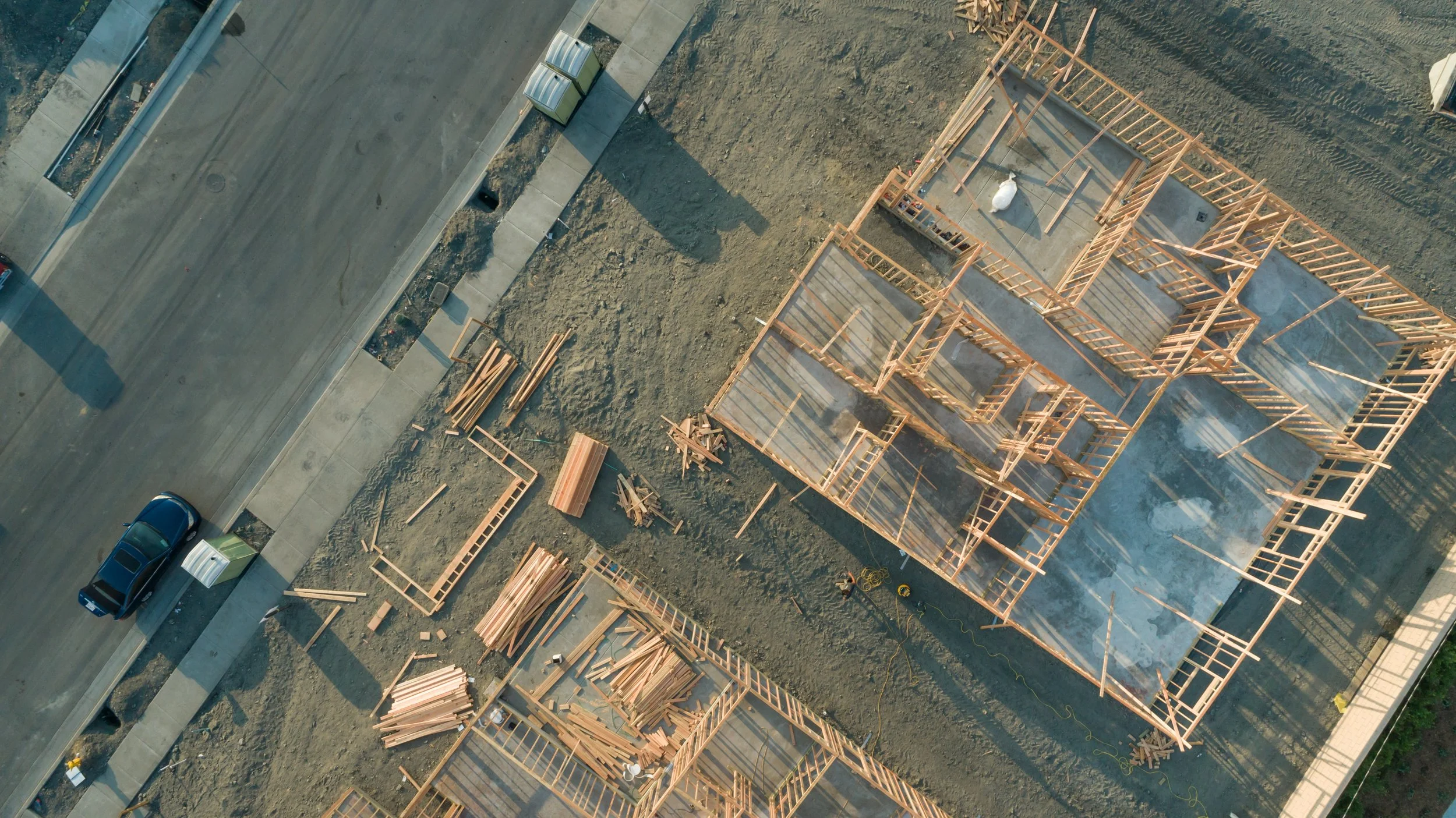
Construction Progress Documentation

Drone documentation illustrating multiple phases of residential construction, from foundation work and framing through roofing and project completion.
Consistent aerial documentation helps contractors, developers, architects, and project stakeholders track progress throughout every phase of construction.
Scheduled aerial photography and video create a visual record of project milestones while improving communication, reporting, stakeholder updates, and project oversight.
Drone Mapping, Orthomosaic & Site Documentation Services

High-Resolution Aerial Mapping for Construction, Development & Commercial Projects
Using enterprise-grade drone technology and RTK-enabled workflows, we create high-resolution aerial maps and orthomosaic imagery that provide a comprehensive view of construction sites, development projects, commercial properties, and infrastructure assets.
Orthomosaic maps are generated by combining hundreds of overlapping aerial photographs into a single, highly detailed image. These deliverables provide valuable visual documentation for project planning, progress tracking, site analysis, reporting, and stakeholder communication.
Common Applications
Construction progress tracking
Residential and commercial development sites
Land development documentation
Site planning and project reporting
Property and infrastructure documentation
Asset management and historical record keeping
Why Orthomosaic Mapping?
Traditional aerial photographs provide individual perspectives of a site. Orthomosaic mapping creates a detailed overhead view that allows project teams to visualize entire properties, construction sites, and development projects within a single high-resolution image.
Our RTK-enabled drone workflows deliver accurate, consistent, and professional documentation designed to support project managers, developers, contractors, engineers, architects, and commercial real estate professionals.
Experienced in RTK Smart Oblique and enterprise aerial data collection workflows for commercial construction, industrial, and development projects throughout Southern California.
Roof, Solar & Infrastructure Inspections

Safe and efficient aerial inspections for elevated and hard-to-access assets.
Common Applications
Roof inspections
Solar array documentation
Cell tower imagery
Utility infrastructure documentation
Wind energy asset inspections
Drone technology helps reduce risk, minimize downtime, and provide detailed visual data without the expense and safety concerns associated with traditional inspection methods.
Let’s Discuss Your Project
Whether you need aerial photography, construction progress documentation, orthomosaic mapping, inspections, or commercial real estate imagery, we’re ready to help.
Contact us today to discuss your project requirements, scheduling needs, and deliverables.
Or you can simply…
Andy Dean Photography & Certified Drone Media is fully insured with commercial general liability coverage ranging from $1M to $10M. Proof of insurance is available upon request.